THUNDERSNOW HAS HIT SEATTLE!
As predicted, a strong convergence zone has formed over Puget Sound, producing heavy precipitation and lightning (see radar at 3:30 PM)

The heavy precipitation is driving the freezing/snow levels towards the surface and there is mixed rain/snow here at the UW. Did you notice how the snow was associated with the heaviest precipitation?
Lightning even hit the Space Needle (see below)
Hopefully, the lightning won't get near the overturned truck on I5 loaded with butane....
____________________
It was quite a surprise for many as heavy snow started falling in Seattle around 6:30 AM this morning. The National Weather Service did talk about the potential for rain and snow showers, but the this morning the snow was quite substantial with .5-2.5 inches around Seattle and neighboring communities.

What happened?
An area of particularly heavy precipitation that pushed the snow level to sea level.
When I went out to get the newspaper at 6:30 AM it was actually raining, but as the precipitation intensity increased, snow started mixing in, followed by big wet flakes.
The Camano Island radar shows the culprit (see below): a small area of heavy showers (yellow is moderate intensities). The precipitation is being enhanced over central Puget Sound due to convergence (air coming together) in the lee of the Olympic Mountains (a weak Puget Sound Convergence Zone).

The freezing level at 5:30 AM was at roughly 1300 ft, but near-freezing temperatures were found down to around 500 ft. As a rule of thumb, the snow level (the level at which all snow from aloft melts) is roughly 1000 ft below the freezing level. So we were close,

Why were the snowflakes so big? Because at marginal temperatures at or near freezing snowflakes are more "sticky" and they tend to form large aggregates of smaller snowflakes.
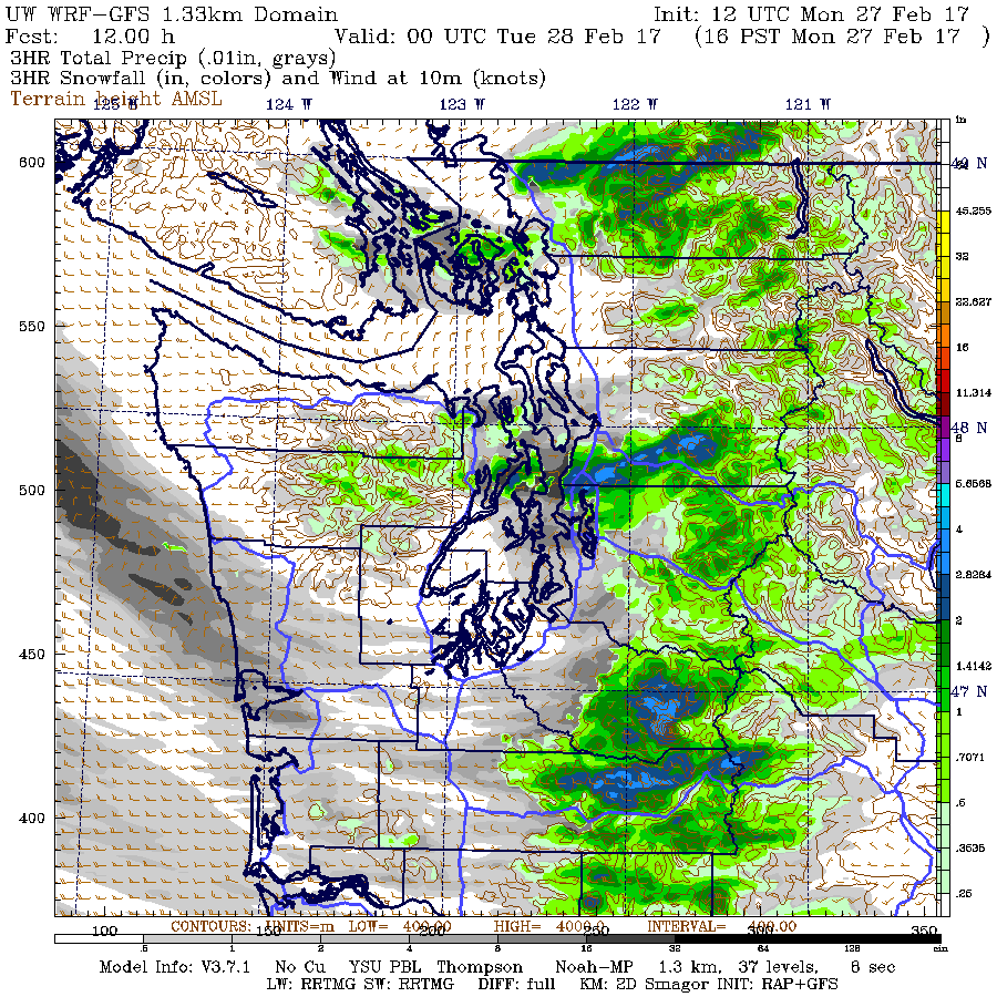
Roads should improve and daytime solar heating will ensure that temperatures rise by early afternoon. But there are some more showers moving in that could cause some snow showers. And there is another chance of significant snow later this afternoon as a Puget Sound Convergence Zone forms north of the city (see snowfall forecast for the 3-hr ending 4 PM). This graphic shows where snow is expected (green/blue colors) and rainfall (gray shades). Only where the intensities (and thus cooling due to melting) is there snow. Where light precipitation exists, there is rain.
___________________
The Northwest Weather Workshop
And don't forget...if you want to attend the big weather meeting of the year...the Northwest Weather Workshop on March 3-4 in Seattle...you have to register before. The agenda and more information (including how to register) is found here: https://www.atmos.washington.edu/pnww/


Ok, I ordinarily love snow, but a surprise this late in February is not that welcome!
ReplyDeleteCome on Spring!
Left home (Columbia City in Seattle) at 5am and it was snowing pretty heavily and it decreased as I went north to Everett just to have it pick up again and fall heavily again... loving this surprise snowfall!
ReplyDeleteI have been a devoted reader of your blog for years, but I don't ever remember you addressing this question (possibly because it is just a bunch of bunk): When I was growing up in Eastern WA (Walla Walla), my mom seemed to be able to accurately predict snow every single time it happened. She did it by looking for what she called a "snow sky." According to her, in order for it to snow the sky needed to be (1) a particular shade of gray and (2) be completely smooth, i.e. no cloud bumps could be seen clear to the horizon. Once these criteria had been met, and assuming the weather was cold enough, then the potential for snow was very high. And by golly, she was nearly always right!
ReplyDeleteI am wondering if there is any scientific truth to this observation, which had been passed down to her from her father, and for I don't know how many generations before that. Is there such a thing as a "snow sky?"
snow must've been preceded by ice, as some of the roads near kenmore/kirkland had 1/2" of ice on them. lots of cars in the ditch. excellent forecast and public notification.
ReplyDeleteLooks like the ECMWF did a pretty good job if forecasting this event about ten days back.Interestingly,it is again hinting at cold upper level heights favorable for more localized snow by about next Sunday.Don't put away your snow shovels yet!
ReplyDeleteSnowing cats and dogs On Orcas Island....4 inches at 800 feet on Mount Constitution and counting at noon today! Where the heck did this come from?
ReplyDelete3" of snow on San Juan island at 500' above sea level. We watched it march in out of the Strait of Georgia over Victoria. Still snowing and fairly socked in now (inside a cloud). Does "socked in" come from what it would look like if you were in a sock?
ReplyDeleteAt least on the Sunday "miss" it seems the Seattle forecast seemed "certain" about snow....per some of your earlier discussions it would be more helpful if the forecast didn't appear binary. The only way to sense the "who knows" factor is to read differing blogs or the NOAA forecast discussion.
ReplyDeleteSnow appears to be increasing in intensity here in Bellingham. Temp just below freezing at KBLI. More than an inch accumulation in our yard since morning.
ReplyDeleteBrooke - I believe it. Growing up here almost 40 years now, the sky has a particular shade to it when it's going to be a really bad sudden downpour, and a particular shade to it before snow. You get used to the nuances if you are good at noticing detail.
ReplyDeletewell its almost 2 p.m. and still snowing in Bellingham. On the snow sky- I grew up with that concept too, I grew up in northern Illinois. It's a certain look that means it may snow. Its not foolproof, but is often accurate.
ReplyDelete2-3 inches around Bellingham - sticking on the roads right now.
ReplyDeleteAbout 2 inches on the grass and buildings here on E. Victor and Meridian in Bellingham at about 2 PM.
ReplyDeleteSteady wind from the north, seems to be getting stronger.
I am assuming this is a simple Frazer outflow meeting wet weather, which I guess is typical for here.
However, does the Frazer outflow often reach Seattle, which is 90 miles south of where I am sitting?
It's been snowing in Bellingham since around 8:30am, I think, and there's at least 2 inches accumulated in my neighborhood (Columbia/Eldridge). Snowflakes were tiny to start, but got big and fluffy as the day went on. Looks like we're back to small flakes again.
ReplyDeleteEagerly awaiting the post on the thunder snow happening right now!
ReplyDeleteHere in Bellingham, the NWS again missed with the forecast big time. We are close to sea level near the airport and received 3" to 4" of snow. We had strong NE winds yesterday. They moderated to north and northwest today, but that did not stop the snow. It has been below freezing all day. At 9 am, the weather bureau was forecasting 40 degrees by noon with mixed rain and snow. I knew they missed again, like all winter.
ReplyDeleteWe are getting significant snow fall in the Sumas area with 3 inches on the ground. This morning NOAA had us getting little to zero accumulation, now there is a winter storm warning! The forecasting this year has been awful. Our "Snowmageden" started with a 2" forecast in January that ended up being over 2'.
ReplyDeleteSleet storm at SR 99 and N 205th at 3pm today. Wacky stuff.
ReplyDeleteWhen I was growing up in Eastern WA (Walla Walla), my mom seemed to be able to accurately predict snow every single time it happened. She did it by looking for what she called a "snow sky."
ReplyDeleteThat sounds like a situation ripe for confirmation bias.
Brooke: I lived and worked in the Cascades for many years, and we defined "snow sky" exactly as your mother did. The avalanche crews read the weather reports, but they also looked at the sky. Predictive models have improved a lot since then, but there's still a lot to be said for sky-watching--especially when looking at weather on a very local level. Often, snow sky helped us guess that snow would be coming to one valley but not the next one over the ridge.
ReplyDeleteI'd love to hear a ruling on the snow sky as well!
ReplyDeleteI had to drive the LONG away around the lake from Redmond to Queene Anne yesterday for an appointment thanks to the I-5 fiasco that we should be calling TankerGate (or TankerBleed for the rest of us techies).
ReplyDeleteAfterwards, I drive to the BofA, and I park on the backside of the bank in a parking space on a slope. My car is a RWD sports car. I notice the light rain and a slight sensation of a warm temperature in the air. I go inside the bank for a couple of minutes and begin to hear frozen precipitation. Another patron asks "what is that noise?" The bank teller looks towards the glass doors and confirms .. "oh, that is hail".
I finish my business the the teller, and walk outside of the bank just as the hail begins to rain down even harder. I snap a couple of pictures and take some short video clips of the event. The hail is nice and round, about the size of Skittles. I begin to crave some Tropical Skittles and start thinking about Marshawn Lynch for some reason. And then.... the skies REALLY begin to open up.
The hail came down in thick blankets. I begin to fear for lightning, knowing that the ionization in the atmosphere is about to ripen to the point of lightning. I get to my car, and sure enough .. CLACK!!! The first bolt strikes very close to my location! I jump in the car and turn on the engine. I begin to back out of the space, not wanting to get stuck on the slope with my summer tires. It's too late. I cannot see out of my rear window. I feel my car begin to slide sideways towards the car parked to my right. The hail and ice is starting to collect all around me in inches on the ground.
I get out of my car and see and inch and a half of hail. My tires were packing down the ice as I had tried to back out. I am stuck!
I made an attempt to shovel the hail with my window shade. Two more strikes of lightning VERY close by and I give in! I'm stuck. I am trapped on this hill. I am not going anywhere. Realizing how ridiculous I must look with my BMW windows shade being used as a shovel,I lock my car and wait out the madness from a pub.
Along the lines of making short-term forecasts by watching the clouds, I spent a considerable amount of time in the early 1970's living in the Rockies and emulating the lifestyles of 1830's Mountain Men. Other than my Hawken muzzle-loading rifle, everything I had was something I'd either made or gotten by trade with someone who had. Shelter was what I could make with my own hands and an axe.
ReplyDeleteI learned many things wintering in the mountains living like that, but one of them was that you can learn a lot about snow, both snow in the ground and snow in the sky, including how to predict snowfalls with great accuracy. It's amazing what your senses can do when you live in the wild without tech, especially when it's a survival skill.
So when I meet or hear about people these days who are still connected to nature in the way I once was (extremely rare), I appreciate that they have far better short-term weather forecasting ability (for the location they live at) than the weather forecasters sitting in their windowless rooms.
Much later, the same was true for the years I lived on a boat and traveled in wilderness areas. My on-board instruments and my eyes (and nose) told me more about the weather than NOAA weather broadcasts, etc. Weather forecasts were just potentials. Theory, if you will. The soon-to-develop conditions at my location, even when wildly different than forecast, was reality and could be determined with local instruments and my senses. I never held it against NOAA when they were wrong, for I had long ago decided that my survival was a matter of my personal weather forecast, not theirs.
I can't count the times when other boaters made their decisions to pull anchor and continue on their treks back and forth to Alaska, or when to seek shelter, based on satellite downloaded weather data, only to come back in and drop anchor next to the spot I hadn't pulled mine from that day, battered and angry at NOAA for getting it wrong. They didn't understand that with some work they could do much better.
There are some good books out there on PNW marine weather forecasting for sailors where local instruments and observations and understanding of terrain are emphasized. But it is a skill that is becoming a bit like using a sextant in a GPS era.
Echoing my fellow Whatcom County (north county in my case) residents here: our forecasts this winter have been off, repeatedly. This week so far is another case in point.
ReplyDelete